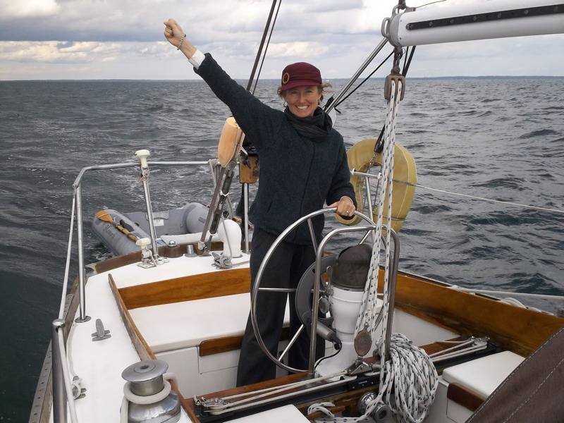
We have launched. We are out in Buzzards Bay, with 12 miles to go to Cuttyhunk harbor. Yay! We have a lovely and strong northwest wind and it is smoother sailing than we expected. So far so good on leg one of the shakedown cruise!
– Capt’n K & Lala
We have launched. We are out in Buzzards Bay, with 12 miles to go to Cuttyhunk harbor. Yay! We have a lovely and strong northwest wind and it is smoother sailing than we expected. So far so good on leg one of the shakedown cruise!
So we didn’t leave yesterday. Captain K was finishing up a project for one of his consulting clients that took a little longer than expected. So we sat in the harbor on wifi until that was completed at 5:00 pm. We just had to make a judgement call, and it simply was more important to finish up the project well than to leave on our initial schedule.
It’s the advice that we’ve heard most often on our journeys, “don’t travel on a schedule.” e.g. be flexible and don’t lock yourself into any specific travel dates. Let the weather and intuition guide you. That has served us well, but it is also maddening. We sat here all day yesterday with perfect ideal beautiful sailing weather. Lots of lovely vessels dropped their mooring lines and hoisted their sails to the masthead and flew away in to the glistening waters of Buzzards Bay. But not us. We sat here grinding our teeth and making much needed money.
C’est la vie, or “Sail a Vie” as some boat names punnily say.
So now we are going to amend our plan to simply this: go out there and then decide where to go. How’s that for a well laid plan!
No, seriously. That seems the best option. It’s powerful out there today. Lots of wind. Lots of gusts. Probably big waves, and the current in the bay will be against us. So maybe we’ll go to Cuttyhunk still as our first stop, but maybe we’ll take a right instead and hug the coast to keep in the less intense wind and then put into Newport, RI. We should be able to post our decision from our iPad 3G while we are out there, but who knows. We might not post again until we are anchored somewhere this evening.
Tomorrow looks like it will be a little bit less powerfully windy, so we’ll decide then if we are heading to New Jersey or going to cruise the Long Island Sound to stay in protected waters before heading to sea.

The Route from Massachusetts to Norfolk
It looks like we are going to get our chance to leave sooner than expected. That’s a nice surprise after these many weeks of waiting for all details to come together. The last thing holding us to land is the sale of my car, and that should be completed by this evening. Wow. So now that we know that this is going to happen, we’ve taken a good long look at the weather forecast and the charts.

Our new big table covered in charts
We have considered going straight from here to Norfolk Virginia. That would be a 72 hour straight line trip that would take us about 100 miles from land at the furthest point. While a great idea in theory, our reality is that we are not feeling up to the challenge right now. So we are going to trust our instincts and stay closer to land where we can find places to anchor at night and do a few shorter legs rather than one huge long one.
We haven’t been able to plan anything until this point because you never know what the weather will do. Now that we know the car is leaving tonight, we can look at the next week’s forecast and make a plan. You can see that plan in the picture. Click on it to see it bigger. Now the lines and points are approximate, but is shows the general course and itinerary.
We plan to take off tomorrow and go to Cutteyhunk Island at the end of the chain of islands in Cape Cod and anchor there for the night. Then the wind should shift to the north and we will shoot fifty miles to the west on Wednesday and anchor in Montauk for the night. Then on Thursday morning we plan to take off for a 155 nautical mile jump to Atlantic City New Jersey. We should arrive on Friday morning or afternoon, so it’s an all day and then all night trip. If we pull in early on Friday, then we can continue on south to Cape May at the southernmost tip of New Jersey to anchor there for the night instead. The last leg of the trip would start on Saturday morning when we plan to jump south for another 155nm trip to arrive at anchorage in Norfolk Virginia sometime on Sunday afternoon.
This route feels much more prudent to us than one straight trip from here to Norfolk. It really will be our shakedown cruise on this new (to us) boat, so it just feels better to stay closer to land and therefore to help if needed. It also gives us the chance to stop and explore an island on the Cape and Montauk before leaving New England for good. It would be tragic to spend all this time here in Massachusetts and not make it to one of the islands on the Cape in our new boat! Her old name is “Nobska Lady” which refers to Nobska Lighthouse on Cape Cod, after all.
We of course might change our plan at any moment based on updated weather information or our energy and endurance levels. Two 155nm legs back to back with one night on anchor in between may prove to be a bit more than we want to do right now. That would mean two 24 hour overnight sails separated by maybe 12 to 24 hours on anchor. Sounds reasonable, but we’ll find out when we get there. We’re hoping that the speed and comfort and easier motion of this boat will allow us to stand longer trips on the ocean. The more 24 hour jumps we can make doing 150 miles at a clip, the faster we’ll get south of the coming cold weather. Maybe we’ll even work our stamina up to doing 48 hour legs along the coast. We’re starting slow and reasonable though rather than biting off more than we may want to swallow. Maybe it would be different if we had a buddy boat, but that hasn’t lined up for us yet.